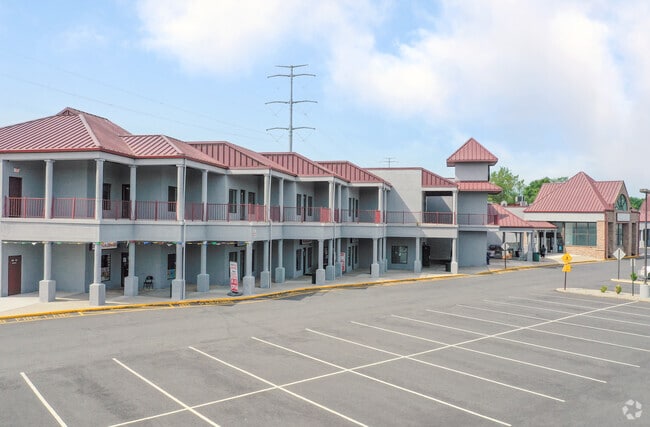
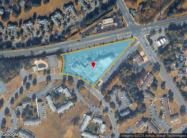
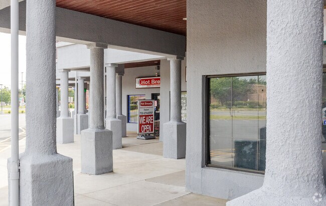
Property Record
485 Georges Rd, Dayton, NJ 08810

NEARBY LISTINGS FOR SALE OR LEASE
Property Detail
485 Georges Rd
New York-Jersey City-White Plains, NY-NJ
5.027 AC STRIP MALL 56,640 SF RENT AREA=51,666 SF
21-00034-04-00053
Middlesex
Regionalshoppingcenterormallwithanchorstore
New Jersey
X
53
34023C0119F
5.03 AC
2024
Brunswick West
2025
Northern New Jersey
008506
DEMOGRAPHICS near 485 Georges Rd
1 Mile
3 Mile
5 Mile
2024 Total Population
8,671
28,653
118,860
2029 Population
8,716
28,619
118,508
Pop Growth 2024-2029
+ 0.52%
(0.12%)
(0.30%)
Average Age
39
40
41
2024 Total Households
2,846
9,824
43,702
HH Growth 2024-2029
+ 0.53%
(0.13%)
(0.44%)
Median Household Inc
$135,582
$120,132
$118,593
Avg Household Size
3.00
2.90
2.70
2024 Avg HH Vehicles
2.00
2.00
2.00
Median Home Value
$417,637
$469,552
$464,632
Median Year Built
1988
1988
1986
Nearby Places
Map Layers
Map Styles
 Street
 Aerial
- Restaurants
- Banks
- Shops
- Fitness
- Groceries
PUBLIC TRANSPORTATION
COMMUTER RAIL
Jersey Avenue (Northeast Corridor Line - NJ Transit Commuter Rail (NJ Transit))
DRIVE
WALK
Distance
Jersey Avenue (Northeast Corridor Line - NJ Transit Commuter Rail (NJ Transit))
22 min
9.5 mi
AIRPORT
Trenton Mercer
DRIVE
WALK
Distance
Trenton Mercer
33 min
21.3 mi
Newark Liberty International
DRIVE
WALK
Distance
Newark Liberty International
50 min
36.8 mi
Freight Ports
New York Container Terminal
DRIVE
WALK
Distance
New York Container Terminal
44 min
29.6 mi
Nearby Properties
Address
Land Use
TOTAL SIZE
Lot Size
Zoning
Address
Land Use
TOTAL SIZE
Lot Size
Zoning
212.16 AC
I-3
Address
Land Use
TOTAL SIZE
Lot Size
Zoning
42.10 AC
LI5
Address
Land Use
TOTAL SIZE
Lot Size
Zoning
80.34 AC
LI5
Address
Land Use
TOTAL SIZE
Lot Size
Zoning
75.55 AC
PL
Address
Land Use
TOTAL SIZE
Lot Size
Zoning
0.46 AC
AH
Address
Land Use
TOTAL SIZE
Lot Size
Zoning
28,155 SF
90.95 AC
I3R4
Address
Land Use
TOTAL SIZE
Lot Size
Zoning
72.62 AC
PL
Address
Land Use
TOTAL SIZE
Lot Size
Zoning
79.67 AC
I-3
Address
Land Use
TOTAL SIZE
Lot Size
Zoning
50.73 AC
I-3
Address
Land Use
TOTAL SIZE
Lot Size
Zoning
3,555 SF
25.73 AC
PL
Address
Land Use
TOTAL SIZE
Lot Size
Zoning
50.34 AC
I-3
Address
Land Use
TOTAL SIZE
Lot Size
Zoning
626,675 SF
54.07 AC
LI-2
Address
Land Use
TOTAL SIZE
Lot Size
Zoning
43.90 AC
I-3
Address
Land Use
TOTAL SIZE
Lot Size
Zoning
23.58 AC
PL
Address
Land Use
TOTAL SIZE
Lot Size
Zoning
34.53 AC
I-3
Address
Land Use
TOTAL SIZE
Lot Size
Zoning
610,949 SF
39.46 AC
I-3
Address
Land Use
TOTAL SIZE
Lot Size
Zoning
21.81 AC
PL
Address
Land Use
TOTAL SIZE
Lot Size
Zoning
521,794 SF
34.63 AC
I-3
Address
Land Use
TOTAL SIZE
Lot Size
Zoning
23.67 AC
I2
Address
Land Use
TOTAL SIZE
Lot Size
Zoning
Address
Land Use
TOTAL SIZE
Lot Size
Zoning
22.76 AC
I-3
Address
Land Use
TOTAL SIZE
Lot Size
Zoning
45.28 AC
I-3
Address
Land Use
TOTAL SIZE
Lot Size
Zoning
20 AC
I-3
Address
Land Use
TOTAL SIZE
Lot Size
Zoning
14.19 AC
CRM3
Address
Land Use
TOTAL SIZE
Lot Size
Zoning
29.01 AC
I-3
Address
Land Use
TOTAL SIZE
Lot Size
Zoning
9.64 AC
I-3
Address
Land Use
TOTAL SIZE
Lot Size
Zoning
34.73 AC
I-3
Address
Land Use
TOTAL SIZE
Lot Size
Zoning
33.44 AC
I-3
Address
Land Use
TOTAL SIZE
Lot Size
Zoning
31.73 AC
I-3
Address
Land Use
TOTAL SIZE
Lot Size
Zoning
20.69 AC
I-3
The World's #1 Commercial Real Estate Marketplace
Connect with us
© 2025 CoStar Group
The information above has been obtained from sources believed reliable. While we do not doubt its accuracy we have not verified it and make no guarantee, warranty or representation about it. It is your responsibility to independently confirm its accuracy and completeness. Any projections, opinions, assumptions, or estimates used are for example only and do not represent the current or future performance of the property. The value of this transaction to you depends on tax and other factors which should be evaluated by your tax, financial, and legal advisors. You and your advisors should conduct a careful, independent investigation of the property to determine to your satisfaction the suitability of the property for your needs.